Table of Contents
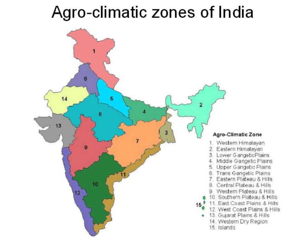
India is divided into different agro-climatic zones to improve how agriculture is managed across the country. This classification started in the late 1990s and looks at factors like land features, climate, soil type, and geography. In 1988, the Planning Commission identified 15 main zones based mainly on landforms. These zones are important for planning farming because they help decide which crops and farming methods work best in each area.
Each agro-climatic zone is also split into smaller sub-regions to make agricultural planning more precise. To learn more about these zones and their sub-regions, keep reading the article.
Agro-Climatic Zones of India
According to the Food and Agriculture Organization (FAO), an agro-climatic zone is a type of land that has a similar climate and growing period, making it suitable for specific crops. These zones have similar weather and farming potential, which helps determine the best crops for each area.
Factors like climate, rainfall, soil type, and which crops grow well together all affect the boundaries of these zones. By identifying these zones, it becomes easier to create targeted plans for agricultural development that match the conditions of each region. This helps use resources more efficiently and improves planning for crop production and farming practices.

Objectives of Agro-Climatic Regions
- To optimize agricultural production and strategies
- To evaluate the agricultural potential and constraints of various regions
- To encourage crop rotation and diversification
- To recognize and solve the problems that farmers encounter
- To improve each region’s efficient use of its resources
- To encourage regional collaboration in agricultural development
- To create agricultural policies programs and incentives
- To encourage the preservation of each region’s natural resources
Agro-Climatic Zones
After reviewing the Seventh Plan, the Planning Commission divided India into fifteen main agro-climatic zones. This classification considered various factors like land features, soil types, geological formations, climate, crop patterns, and the development of irrigation and mineral resources. The purpose of these zones is to help with agricultural planning and to create strategies for the future.
Along with the fifteen main zones, there are also 72 smaller sub-zones that provide more detail for planning agriculture. Fourteen of the main zones are on the mainland of India, while one is located on the islands in the Bay of Bengal and the Arabian Sea.
For a detailed understanding of these fifteen agro-climatic zones, refer to the table below:
| Agro-Climatic Zones of India | ||
| Zone | Region | States/Union Territories Included |
| 1 | Western Himalayan Region | Jammu and Kashmir, Uttar Pradesh |
| 2 | Eastern Himalayan Region | Assam, Sikkim, West Bengal, and all North-Eastern states |
| 3 | Lower Gangetic Plains Region | West Bengal |
| 4 | Middle Gangetic Plains Region | Uttar Pradesh, Bihar |
| 5 | Upper Gangetic Plains Region | Uttar Pradesh |
| 6 | Trans-Gangetic Plains Region | Punjab, Haryana, Delhi, Rajasthan |
| 7 | Eastern Plateau and Hills Region | Maharashtra, Uttar Pradesh, Orissa, West Bengal |
| 8 | Central Plateau and Hills Region | Madhya Pradesh, Rajasthan, Uttar Pradesh |
| 9 | Western Plateau and Hills Region | Maharashtra, Madhya Pradesh, Rajasthan |
| 10 | Southern Plateau and Hills Region | Andhra Pradesh, Karnataka, Tamil Nadu |
| 11 | East Coast Plains and Hills Region | Orissa, Andhra Pradesh, Tamil Nadu, Pondicherry |
| 12 | West Coast Plains and Ghat Region | Tamil Nadu, Kerala, Goa, Karnataka, Maharashtra |
| 13 | Gujarat Plains and Hills Region | Gujarat |
| 14 | Western Dry Region | Rajasthan |
| 15 | The Islands Region | Andaman and Nicobar Islands, Lakshadweep |
Features of Agro-Climatic Zones
There are 15 Agro-Climatic Zones in India. Features of each zone are provided below.
Zone 1: Western Himalayan Region
| Features | Description |
| Location | Jammu and Kashmir, Himachal Pradesh, Kumaun-Garhwal areas of Uttarakhand. |
| Climate | Mild summers (July avg. temp: 5°C-30°C), severe winters (Jan temp: 0°C to -4°C). |
| Soil | Valleys- Thick alluvium, Hill slopes- Thin brown hilly soils. |
| Crops | Main crops: maize, wheat, potato, barley. Temperate fruits in parts of Jammu Kashmir and Himachal Pradesh. |
Zone 2: Eastern Himalayan Region
| Features | Description |
| Location | Sikkim, Darjeeling area (West Bengal), Arunachal Pradesh, Assam hills, Nagaland, Meghalaya, Manipur, Mizoram, Tripura. |
| Climate | Sub-humid climate, with rainfall over 200 cm and temperatures ranging from 25°C to 33°C in July and 11°C to 24°C in January. |
| Soil | Brownish, thick layered, and less fertile soil. |
| Agricultural Practice | Shifting cultivation (Jhum) (1/3 of the cultivated area) |
| Main Crops | Rice, potato, maize, tea, and fruits such as orange, pineapple, lime, and litchi. |
Zone 3: Lower Gangetic Plains Region
| Features | Description |
| Location | Eastern Bihar, West Bengal, and Assam Valley. |
| Climate | July: 26°C – 41°C, January: 9°C – 24°C. |
| Soil | Alluvial Soils |
| Main Crops | Rice is the main crop, with three successive crops (Aman, Aus, and Boro) in a year. |
Zone 4: Middle Gangetic Plains Region
| Features | Description |
| Location | Eastern Uttar Pradesh and Bihar (except the Chotanagpur plateau). |
| Climate | July: 26°C – 41°C, January: 9°C – 24°C. |
| Soil | Alluvium derived like Khaddar and Bhangar |
| Main Crops (Kharif Season) | Rice, maize, millet. |
| Main Crops (Rabi Season) | Wheat, gram, barley, peas, mustard, potato. |
Zone 5: Upper Gangetic Plains Region
| Features | Description |
| Location | Central and western parts of Uttar Pradesh. |
| Climate | Sub-humid continental with July temperature between 26°C – 41°C, January temperature between 7°C – 23°C, and average annual rainfall between 75 cm – 150 cm. |
| Soil | Sandy loam soil. |
| Main Crops | Wheat, rice, sugarcane, millets, maize, gram, barley, oilseeds, pulses, and cotton. |
Zone 6: Trans-Gangetic Plains Region
| Features | Description |
| Location | Punjab, Haryana, Delhi, Chandigarh, and Ganganagar districts of Rajasthan. |
| Climate | Semi-arid characteristics with July temperature between 26°C – 42°C, January temperature between 7°C – 22°C, and average annual rainfall between 70 cm – 125 cm. |
| Soil | Alluvial |
| Main Crops | Wheat, sugarcane, cotton, rice, gram, maize, millets, pulses, and oilseeds. |
Zone 7: Eastern Plateau and Hills Region
| Features | Description |
| Location | Chotanagpur plateau, Rajmahal Hills, Chhattisgarh plains, and Dandakaranya. |
| Climate | July: 26°C – 34°C, January: 10°C – 27°C, Annual rainfall: 80 cm – 150 cm. |
| Soil | Red and yellow soils with occasional patches of laterites and alluviums. |
| Main Crops | Crops like rice, millet, maize, oilseeds, ragi, gram, and potato. |
Zone 8: Central Plateau and Hills Region
| Features | Description |
| Location | Bundelkhand, Baghelkhand, Bhander plateau, Malwa plateau, and Vindhyachal hills. |
| Climate | Semi-arid in the western part to sub-humid in the eastern part. July: 26°C – 40°C, January: 7°C – 24°C, Annual rainfall: 50 cm – 100 cm. |
| Soil | Mixed red, yellow, and black soils. |
| Main Crops | Crops grown include millets, gram, barley, wheat, cotton, sunflower, etc. |
Zone 9: Western Plateau and Hills Region
| Features | Description |
| Location | Southern part of the Malwa plateau and Deccan plateau (Maharashtra). |
| Climate | July: 24°C – 41°C, January: 6°C – 23°C, Annual rainfall: 25 cm – 75 cm. |
| Soil | Shallow to medium and deep black soils with sandy loam to loamy texture and neutral reaction |
| Main Crops | Jowar, cotton, sugarcane, rice, bajra, wheat, gram, pulses, potato, groundnut, and oilseeds. |
| Special Crops | Known for oranges, grapes, and bananas. |
Zone 10: Southern Plateau and Hills Region
| Features | Description |
| Location | Southern Maharashtra, Karnataka, western Andhra Pradesh, and northern Tamil Nadu. |
| Climate | July: 26°C – 42°C, January: 13°C – 21°C, Annual rainfall: 50 cm – 100 cm. |
| Soil | Low-level valleys and regions are covered by black soils, while red soils on higher slopes and hilltops are seen |
| Main Crops | Low-value cereals and minor millets predominate. |
| Special Crops | Coffee, tea, cardamom, and spices are grown along the hilly slopes of the Karnataka plateau. |
Zone 11: East Coast Plains and Hills Region
| Features | Description |
| Location | Coromandel and Northern Circar – the important Coastal plains of India. |
| Climate | Sub-humid maritime, May temperature: 26°C – 32°C, January temperature: 20°C – 29°C, Annual rainfall: 75 cm – 150 cm. |
| Soil | Alluvial, loam, and clay, with the problem of alkalinity. |
| Main Crops | Rice, jute, tobacco, sugarcane, maize, millet, groundnut, and oilseeds. |
Zone 12: West Coast Plains and Ghat Region
| Features | Description |
| Location | Malabar and Konkan coasts and the Sahyadris. |
| Climate | Humid, annual rainfall above 200 cm. July temperature: 26°C – 32°C, January temperature: 19°C – 28°C. |
| Soil | Laterite and Coastal Alluvials |
| Main Crops | Rice, coconut, oilseeds, sugarcane, millets, pulses, cotton. |
| Special Crops | Famous for plantation crops and spices raised along the hill slopes of the Ghats. |
Zone 13: Gujarat Plains and Hills Region
| Features | Description |
| Location | Kathiawar and fertile valleys of the Mahi and Sabarmati rivers. |
| Climate | Arid and semi-arid, annual rainfall: 50 cm – 100 cm. July temperature: 26°C – 42°C, January temperature: 13°C – 29°C. |
| Soil | Regur in the plateau region, alluvium in the coastal plains, and red and yellow soils in Jamnagar. |
| Main Crops | Groundnut, cotton, rice, millet, oilseeds, wheat, and tobacco. |
| Specialty | Important oilseed producing region. |
Zone 14: Western Dry Region
| Features | Description |
| Location | Western Rajasthan west of the Aravallis. |
| Climate | Hot sandy desert, erratic rainfall (annual average less than 25 cm), high evaporation. June: 28°C – 45°C, January: 5°C – 22°C. |
| Soil | Red, Laterite, and Coastal Alluvial Soil with loam and clay loam soil texture and acidic reaction |
| Main Crops | Kharif: Bajra, jowar, moth; Rabi: Wheat, gram. |
Zone 15: The Islands Region
| Features | Description |
| Location | Andaman-Nicobar and Lakshadweep islands. |
| Climate | Typically equatorial, annual rainfall is less than 300 cm. July temperature: 30°C, January temperature: 25°C. |
| Soil | Sandy along the coast, clayey loam in valleys and lower slopes. |
| Main Crops | Rice, maize, millet, pulses, areca nut, turmeric, cassava. |
| Significant Crop | Nearly half of the area is under coconut cultivation. |


 BSSC Field Assistant Recruitment 2025 No...
 Bihar BSSC Field Assistant Salary 2025, ...
 JCI Recruitment Syllabus 2025, Check for...


 Adda247 Job portal has complete information about all Sarkari Jobs and Naukri Alerts, its latest recruitment notifications, from all state and national level jobs and their updates.