Table of Contents
The expected Class 12 Geography board exam paper created by the experts contains the questions that can appear in the actual board exam paper. The expected board paper of the Class 12 Geography has been made by experts who have years of teaching experience and formulating board exam papers. The board exam paper has been made by carefully analyzing the previous exam pattern and the latest curriculum.
A comprehensive awareness of both physical and human geography, as well as the capacity to apply geographical ideas to practical situations, are prerequisites for class 12 geography. Students can improve their exam readiness by predicting the possible format of the 2024 board paper, concentrating on important chapters, and preparing with a variety of question forms.
Class 12 Geography Board Exam Paper 2024
Expected Class 12 Geography Board Exam Paper 2024: The CBSE Class 12 Geography Examination is going to take place on 29th February 2024. So it is a very crucial time to maximize our score in the Class 12 Geography Exam. Students must practice the Model Class 12 Geography Board Exam Paper 2024 for Geography as much as they can, it will beneficiary to face the questions in the Examination hall.
For the benefit of the class 12 candidates, Our Adda247 Expert faculty prepare the Expected Class 12 Board Geography Exam Paper 2024 which is based on the real CBSE Class 12 Exam pattern. Candidates who are going to take class 12 must go through the Class 12 Geography Board Exam Paper 2024 given below in the article.
Geography Class 12 Board Question Paper 2024- Expected
Adda247’s Class 12 Board Geography Exam Paper 2024, like the official CBSE Class 12 Geography sample paper, comprises four sections with 30 questions for an overall score of 80. Check out the below mark distribution for the Class 12 Board Geography Exam Paper 2024.
I. Question paper comprises four Sections – A, B, C, D . There are 30 questions in the question paper. All questions are compulsory.
II. Section A – Questions 1 to 17 are MCQs of 1 mark each.
III. Section B – Questions no. 18 to 23 are Short Answer Type Questions, carrying 3 marks each. Answers to each question should not exceed 60-80 words.
IV. Section C – Questions no 24 to 28 are Long Answer Type Questions, carrying 8 marks each. Answers to each question should not exceed 300-350 words.
V. Section D – Questions no.29 to 30 are Source based questions with three sub-questions and are of 4 marks each
Class 12 Geography Board Exam Paper 2024 Section A
SECTION-A
Q1. What does Human geography mean?
(a) People and Environment interact with each other
(b) People and Environment distract with each other
(c) People destroy the Environment
(d) None of the above
Ans. (a)
Sol. Human geography is a branch of geography. It studies how people and the environment have an effect on each other.
Q2. Which of the following concepts are introduced by the Austrian Geographer Griffith Taylor?
(a) One-way Path
(c) Bi-polar Path
(c) Middle Path
(d) All of the above
Ans. (c)
Sol. A geographer, Griffith Taylor introduced another concept which reflects a middle path (Madhyam Marg) between the two ideas of environmental determinism and possibilism.
Q3. What is the population density?
(a) The ratio between population numbers and world size
(b) The ratio between number of Cities and world size
(c) The ratio between male and female
(d) None of the above
Ans. (a)
Sol. Population density: The ratio between population numbers and world size. This measure is overcrowding. It is usually measured by people per sq. M. km.
Q4. What is the factor affecting Population Distribution?
(a) Geographical Condition
(b) Social and Culture Factor
(c) Economic Factor
(d) All of the above
Ans. (d)
Sol. The factor affecting of population distributions are
1. Geographical Factor
2. Social and Culture Factor
3. Economics Factor
Q5. What does migration mean?
(a) Tourist who move from one place or region to another
(b) Migration is a continuous movement of a person from one place or region to another
(c) Migration is a discontinuous movement of a person from one place or region to another
(d) All of the above
Ans. (b)
Sol. Migration is a continuous movement of a person from one place or region to another.
Q6. What does Population composition mean?
(a) Population Composition is a separate field of research between a historic and geographic
(b) Population Composition is a separate field of research between a politics and geographic
(c) Population Composition is a separate field of research between a Socialist and geographic
(d) Population Composition is a separate field of research between a demographic and geographic
S6. Ans. (d)
Sol. Population Composition is a separate field of research between a demographic and geographic, geographical, ethnic, ethnic, linguistic, religious, marital status, literacy and education, occupational characteristics, etc.
Q7. What is the process of human development?
(a) Freedom and Opportunity
(b) Freedom and Same Culture
(c) Freedom and Distributed Culture
(d) Freedom and Sociology
Ans. (a)
Sol. The purpose of human development is the process of increasing people’s freedom and opportunity and improving their well-being
Q8. In India, which organization published the Human Development Index?
(a) Ministry of Home
(b) Ministry of Urban Housing and Development
(c) Ministry of Social Justice
(d) NITI Ayog
Ans. (d)
Q9. In India, which of the following states become 3rd most densely populous state in India?
(a) Uttar Pradesh
(b) Maharashtra
(c) Bihar
(d) Rajasthan
S9. Ans. (c)
In India, Bihar has become the 3rd most densely populated state.
Q10. Which of the following states in India is considered as the most literate states?
(a) Kerala
(b) Bihar
(c) Andhra Pradesh
(d)Tamil Nadu
Ans. (a) Kerala
Q11. What does Herding mean?
(a) Rearing of domestic bird
(b) Rearing of animals in the pastures
(c) Hunting of animals
(d) All of the above
Ans. (b)
Sol. Herding means the rearing and rearing of animals in the pastures.
Q12. Dr. Mehbub-ul-Haq belongs to which country?
(a) Sri lanka
(b) Afghanistan
(c) Bangladesh
(d) Pakistan
Ans. (d)
Q13. How many types of Subsistence agriculture are divided?
(a) One
(b) Two
(c) Three
(d) Four
Ans. (b)
Sol. Subsistence Agriculture is one in which the agricultural areas use all the products grown in the area. It can be divided into two categories
1. Primitive Subsistence Agriculture and
2. Intensive Subsistence Agriculture.
Q14. Primitive agriculture is practiced in the northern state in India. Which of the following names is famously known?
(a) Jhumming
(b) Milpa
(c) Ladang
(d) All of the above
Ans. (a)
Read the following case study and answer questions no 15 to 17.
Darbhanga is a district of Bihar. It has become an example for watershed development throughout the country. In 1999, Darbhanga was caught in a web of poverty and illicit liquor trade. The transformation took place when a retired Professor settled down in the district and took up the task of watershed development. He convinced people of Darbhanga about the importance of family planning and voluntary labour; preventing open grazing, felling trees, and liquor prohibition. Voluntary labour was necessary to ensure minimum dependence on the
government of Bihar for financial aid. Even those who were working outside the district also contributed to the development by committing a month’s salary every year. Work began with the percolation tank constructed in the village. In 2004, the tank could not hold water. The embankment wall leaked. People voluntarily repaired the embankment. The seven wells below it swelled with water in summer for the first time in the living memory of the people. The people reposed their faith in him and his visions. A youth group called Shiv Mandal was
formed. The group worked to ban the dowry system, caste discrimination and un-touch ability. Liquor distilling units were removed and prohibition imposed. Open grazing was completely banned with a new emphasis on stall feeding. The cultivation of water intensive crops like sugarcane was banned. Crops such as pulses, oilseeds and certain cash crops with low water requirements were encouraged. All elections to local bodies began to be held on the basis of consensus. “It made the community leaders complete representatives of the people.” A
system of Nyay Panchayats (informal courts) were also set up. Since then, no case has been referred to the police. A Rs. 14 lakh school building was constructed using only the resources of the village. Money, if needed, was borrowed and paid back.
Q15. Which of the following methods of water conservation brought prosperity in Darbhanga?
(a) Flood water storage
(b) Watershed development
(c) Rainwater Harvesting
(d) None of the above
Ans. (b)
Q16. Who took up the task of watershed development in the Darbhanga district?
(a) Retired Doctor
(b) Retired Engineer
(c) Retired Professor
(d) People who live in the Darbhanga district
Ans. (c)
Sol. The transformation took place when a retired Professor settled down in the district and took up the task of watershed development.
Q17. How many school buildings were constructed by using only the resources of the village?
(a) 14 Crore
(b) 14 Thousand
(c) 14 Lakh
(d) None of the above
Ans. (c)
Class 12 Geography Board Exam Paper 2024 Section B
SECTION B
Read the given Passage carefully and answer the questions that follow:
Bharmour tribal area comes under the Chamba district of Himachal Pradesh. It has been a notified tribal area since November 21,1975 by the Government of India. Bharmour is inhabited by “Gaddi tribes‟. Gaddi is a tribal community who have maintained a distinct identity in the Himalayan region as they practiced trans-humance and conversed through their own dialect which is known as Gaddiali dialect. Bharmour tribal region falls under the harsh climate conditions and these tribes survive under the harsh climate with low resource base and fragile environment.
According to the 2011 census, the total population of Bharmour sub-division was 39,113 i.e., 21 persons/square kilometer. It is one of the most economically and socially backward areas of Himachal Pradesh that has been declared by the Government. Historically, the Gaddis have experienced geographical and political isolation and socio-economic deprivation. The economy is largely based on agriculture and allied activities such as sheep and goat rearing. The process of development of the tribal area of Bharmour started when Gaddis were included
among „scheduled tribes‟. The Bharmour region of Himachal Pradesh was designated as one of the five Integrated Tribal Development Projects (ITDP) under the Fifth Five Year Plan. This tribal sub-plan was introduced in 1974. This development plan was aimed at improving the quality of life of the Gaddis and narrowing the gap in the level of development between Bharmour and other areas of Himachal Pradesh.
Q18(A). Gaddis tribe belongs to which states of India?
Q18 (B). What is the aim of the Integrated Tribal Development Project?
Q19. Observe the given map and answer the following questions
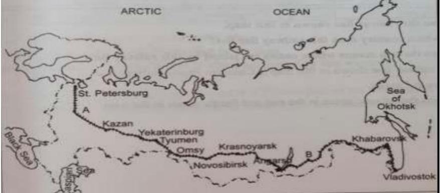
Q19. Name the country that belongs to this railway line that lies in the above maps?
Q20. What is the shifting cultivation?
Q21. What is Plantation agriculture?
Q22. What do you understand about viticulture?
Q23. What do you understand about mechanization?
Class 12 Geography Board Exam Paper 2024 Section C
SECTION C
Q24. Describe the term ‘Size Based Industries’ and its types?
Q25. Explain how tourism is a part of the service sector?
Q26. Describe the classification of Urban settlement?
Q27. Explain the Cotton textile industry and also describe the distribution of the Cotton textile Industry?
Q28. Describe the Urban Settlement problem.
Expected Class 12 Board Geography Exam Paper 2024 Section D
SECTION-D
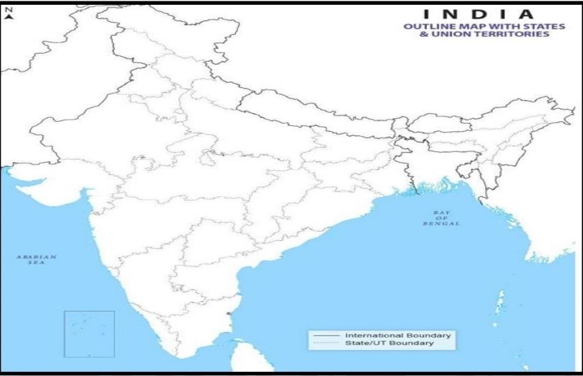
Q29. On the given political map of the world, the following features are shown. Identify all of these features and mark their location on each feature.
(a) Jawahar lal Port
(b) Haldia Port
(c) Bokaro Steel Plant
(d) Odisha Bauxite Mines
(c) Tummalapalle Uranium Mine
(e) Musi River City
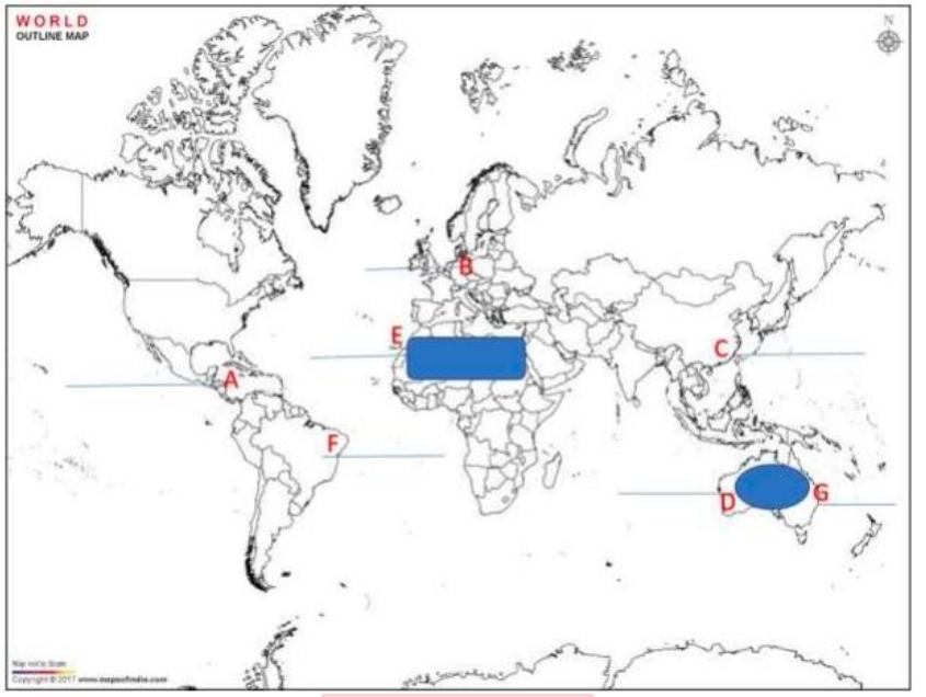
Q30. On the given political map of the World, locate and write the country name of the following alphabets?
Class 12 Geography Board Exam Paper 2024- With Solutions
We have also provided you with detailed solutions for Geography Class 12 Board Question paper 2024. So, after solving the Expected Class 12 Geography board Question paper 2024, students can analyze their scores.
| Class 12 Geography Expected Question Paper With Solutions Download |
Class 12 Geography Sample Paper 2024 With Solutions
Solving the CBSE Class 12 Geography sample paper 2024 is important from the examination point of view. So, we have provided the solutions of the Class 12 geography sample paper solutions 2024. Students can analyze the answers provided in the given video with their answers and work on improving their answer writing techniques.



 NEET City Intimation Slip 2025 Available...
 PSEB Punjab Board 12th Result 2025 @pseb...
 HPBOSE 12th Result 2025 Out Soon @hpbose...


