Table of Contents
Highest Peak of India k2 or Kanchenjunga
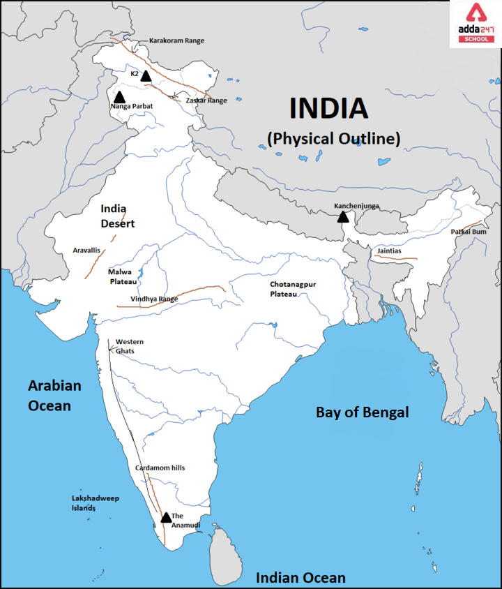
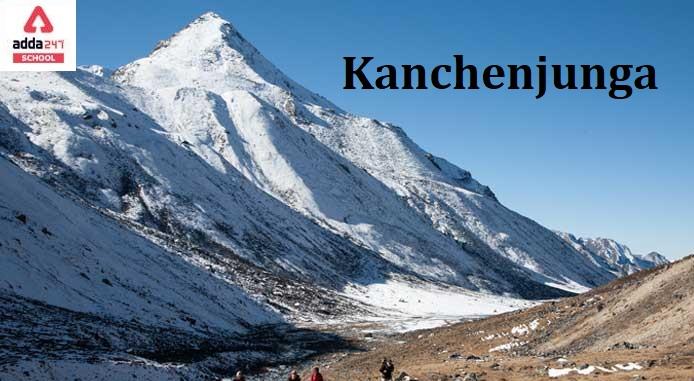
Kanchenjunga is the highest peak of India and it is the world’s third-highest peak, rising 8,586 meters(28,169 feet) above sea level. Kanchenjunga is located 46 miles north-northwest of Darjiling, Sikkim, on the boundary of Sikkim, northeastern India, and eastern Nepal. Kanchenjunga is located in the Great Himalayas Range and is home to many animals. The Kanchenjunga massif is shaped like a massive cross, with arms extending north, south, east, and west. Until 1852, Kangchenjunga was considered to be the highest peak in the world, but calculations based on numerous readings and measurements taken by the Great Trigonometrical Survey of India in 1849 determined that Mount Everest is the highest. Kangchenjunga was officially declared the world’s third highest peak in 1856. In this article, we have discussed the highest peak of India in detail. Stay tuned and bookmark this page.
Highest Peak of India: Kanchenjunga
The meaning of Kanchenjunga is “The Five Treasures of Snows” (namely grain, gold, gems, silver, and holy books). The Kangchenjunga region has five peaks above 7,000 meters, while the area has 12 additional peaks over 7,000 meters (23,000 ft).
Highest Peak of India: Overview
Below we have given a brief description of the highest peak of India i.e. Kanchenjunga. Check out the table below:
| Name | Kanchenjunga |
| Height | 8,586 meters |
| World Rank | 3rd Highest peak |
| Mountain Range | The Great Himalayan Range |
| Location | Sikkim |
Highest Peak of India in Map

Top 10 Highest Peak of India Peninsula
The highest peak of India is Kangchenjunga with a height of 8586 meters. We have given the top 10 highest peaks of India with their height in the below table. Check out the table below:
| Mountain Peak | Height |
| K2 | 8611 meters |
| Kangchenjunga | 8586 meters |
| Nanda Devi | 7816 meters |
| Kamet | 7756 meters |
| Saltoro Kangri | 7742 meters |
| Saser Kangri | 7672 meters |
| Mamostong Kangri/Mamostang Kangri | 7516 meters |
| Rimo I | 7385 meters |
| Hardeol | 7151 meters |
| Chaukhamba I | 7138 meters |
| Trisul I | 7120 meters |
Highest Peak of India in Himalayas
The Kangchenjunga is located in both Nepal and India and has 16 peaks that rise beyond 7,000 meters (23,000 ft). It is bounded to the north by the Jongsang La, Lhonak Chu, and Goma Chu and to the east by the Teesta River. The western boundary of Kangchenjunga extends from the Jongsang La, down the Gingsang and Kangchenjunga glaciers, and down the Ghunsa and Tamur rivers. Kanchenjunga rises roughly 20 kilometers (12 miles) south of the general alignment of the Great Himalayan range, around 125 kilometers (78 miles) east-southeast of Mount Everest. The 3,000–3,500 m (9,800–11,500 ft) high Singalila Ridge, which divides Sikkim from Nepal and northern West Bengal, runs south of Kanchenjunga’s southern face. Kangchenjunga and its subsidiary summits combine to form a massive mountain massif. The five highest peaks of the massif are mentioned in the table below.
| Name of peak | Height (m) | Height (ft) | Prominence (m) | Prominence (ft) |
| Kangchenjunga West (Yalung Kang) | 8,505 | 27,904 | 135 | 443 |
| Kangchenjunga South | 8,494 | 27,867 | 119 | 390 |
| Kangchenjunga Main | 8,586 | 28,169 | 3,922 | 12,867 |
| Kangchenjunga Central | 8,482 | 27,828 | 32 | 105 |
| Kangbachen | 7,903 | 25,928 | 103 | 337 |
Highest Peak of India: Mountains of India with their States
There are other prominent mountain peaks in India that exist in different states of India. In the table below, we have given the lists of the mountain ranges in India, along with the state in which they are situated and their height. Check out the table below:
| Peak | Range/Region | State | Height |
| Arma Konda | Eastern Ghats | Andhra Pradesh | 1680 m |
| Kangto | Eastern Himalaya | Arunachal Pradesh | 7060 m |
| Someshwar Fort | West Champaran District | Bihar | 880 m |
| Bailadila Range | Dantewada District | Chhattisgarh | 1276 m |
| Sonsogor | Western Ghats | Goa | 1166 m |
| Girnar | Junagadh District | Gujarat | 1069 m |
| Karoh Peak | Morni Hills | Haryana | 1467 m |
| Reo Purgyil | Western Himalaya | Himachal Pradesh | 6816 m |
| Parasnath | Parasnath Hills | Jharkhand | 1370 m |
| Mullayanagiri | Western Ghats | Karnataka | 1930 m |
| Anamudi | Western Ghats | Kerala | 2695 m |
| Dhupgarh | Satpura | Madhya Pradesh | 1350 m |
| Kalsubai | Western Ghats | Maharashtra | 1646 m |
| Mount Iso | Senapati District | Border of Manipur and Nagaland | 2994 m |
| Shillong Peak | Khasi Hills | Meghalaya | 1965 m |
| Phawngpui | Saiha District | Mizoram | 2157 m |
| Mount Saramati | Naga Hills | Nagaland | 3826 m |
| Deomali | Eastern Ghats | Odisha | 1672 m |
| Guru Shikhar | Aravalli Range | Rajasthan | 1722 m |
| Kanchenjunga | Eastern Himalaya | Sikkim | 8586 m |
| Doddabetta | Nilgiri Hills | Tamil Nadu | 2637 m |
| Doli Gutta | Deccan Plateau | Border of Telangana and Chhattisgarh | 965 m |
| Betalongchhip | Jampui Hills | Tripura | 930 m |
| Amsot Peak | Shivalik Hills | Uttar Pradesh | 945 m |
| Nanda Devi | Garhwal Himalaya | Uttarakhand | 7816 m |
| Sandakphu | Eastern Himalaya | West Bengal | 3636 m |


 NEET City Intimation Slip 2025 Out at ne...
 CUET Chapter Wise Weightage 2025 for Sci...
 [Live Update] UP Board Result 2025 Class...


