Table of Contents
Western Ghats
The Western Ghats, also known as the Western Mountain range, is a chain of mountains that runs 1,600 km (990 mi) parallel to the western coast of the Indian peninsula and extends over an area of 160,000 km2 (62,000 sq mi). It crosses the states of Gujarat, Maharashtra, Goa, Karnataka, Kerala, and Tamil Nadu. It is one of the eight biodiversity hotspots in the world and a UNESCO World Heritage Site. It is occasionally referred to as the Great Escarpment of India.
Western Ghats Spread Over How Many States
- Western Ghats is home to a significant amount of the nation’s flora and wildlife, including several species that are unique to this area.
- The Western Ghats are older than the Himalayas, according to UNESCO.
- By blocking the rain-filled monsoon winds that arrive from the south-west in the late summer, Western Ghats have an impact on the weather patterns of the Indian monsoon.
- The Deccan Plateau and the Konkan, a slender coastal plain along the Arabian Sea, are divided by the range, which runs north to south along the western side of the plateau.
- Twenty regions in Kerala, ten in Karnataka, six in Tamil Nadu, and four in Maharashtra were included in the total of 39 Western Ghats locations that were given world heritage status in 2012. These locations included national parks, wildlife sanctuaries, and reserve forests.
Western Ghats States
The Western Ghats are home to more than 5,000 blooming plants, 139 animals, 508 bird species, and 179 amphibian species, making them one of the world’s biodiversity hotspots. Here are at least 325 globally endangered species. The 60,000km2 range serves as the catchment basin for a number of interconnected river systems that dredge about 40% of India. The highest mountain in the Western Ghats is Mt. Anamudi in Kerala, India, at 2695 metres. A potential UNESCO World Heritage Site is the Western Ghats.
Western Ghats Mountains
From the Satpura Range in the north, the Western Ghats spread southward from Gujarat to Tamil Nadu. Through the states of Maharashtra, Goa, Karnataka, and Kerala, it travels south. The Goa Gap, which separates the Maharashtra and Karnataka parts, and the Palghat Gap, which separates the Nilgiri Mountains and the Anaimalai Hills on the Tamil Nadu and Kerala border, are the two largest gaps in the range.
- Because the mountains block the rain-producing westerly monsoon winds, they get significant rainfall, especially on their western side.
- By serving as a substrate for the condensation of moist ascending orographic winds from the sea and releasing a large portion of the moisture back into the atmosphere through transpiration, the dense woods in the region also contribute to the precipitation.
- The Deccan Plateau’s hilly, faulted, and eroded edge is known as the Western Ghats.
- Geological evidence suggests that they were created 150 million years ago, with the disintegration of the supercontinent Gondwana.
Western Ghats Highest Peaks
The Cardamom Hills, also known as Yela Mala, are the tallest mountains in southern India and are a component of the southern Western Ghats. They are situated in the Keralan district of Idukki. Their name derives from the cardamom spice, which is grown in large quantities in the cold elevation of the hills, along with pepper and coffee.
Here is the list of top 20 highest peaks of the Western Ghats:
| S. No. | Peak | Height | Location | State |
| 1 | Anamudi | 2,695 m (8,842 ft) | Eravikulam National Park | Kerala |
| 2 | Mannamala | 2,659 m (8,724 ft) | Idukki-Theni | Kerala-Tamilnadu |
| 3 | Meesapulimala | 2,640 m (8,660 ft) | Idukki-Theni | Kerala-Tamilnadu |
| 4 | Doddabetta | 2,637 m (8,652 ft) | Nilgiris | Tamilnadu |
| 5 | Kolaribetta | 2,629 m (8,625 ft) | Mukurthi National Park | Tamil Nadu |
| 6 | Makurni Peak | 2,594 m (8,510 ft) | Nilgiris | Tamil Nadu/Kerala |
| 7 | Mukurthi | 2,554 m (8,379 ft) | Mukurthi National Park | Tamil Nadu/Kerala |
| 8 | Vandaravu | 2,553 m (8,376 ft) | Palani Hills | Tamil Nadu/Kerala |
| 9 | Kattumala | 2,552 m (8,373 ft) | Eravikulam National Park | Kerala |
| 10 | Snowdon |
2,530 m (8,300 ft) |
Nilgiris | Tamil Nadu |
| 10 | Devimala | 2,523 m (8,278 ft) | Devikulam | Kerala |
| 11 | Kumarikkal Mala | 2,522 m (8,274 ft) | Chinnar Wildlife Sanctuary | Kerala |
| 12 | Kulkudi | 2,439 m (8,002 ft) | Nilgiris | Tamil Nadu |
| 13 | Kattadadu | 2,418 m (7,933 ft) | Nilgiris | Tamil Nadu |
| 14 | Perumal Malai | 2,234 m (7,329 ft) | Kodaikanal | Tamil Nadu |
| 14 | Eravimala | 2,401 m (7,877 ft) | Idukki | Kerala |
| 15 | Anginda peak | 2,383 m (7,818 ft) | Nilgiris | Tamil Nadu |
| 16 | Hecuba | 2,375 m (7,792 ft) | Nilgiris | Tamil Nadu |
| 16 | Nandala Mala | 2,372 m (7,782 ft) | Chinnar Wildlife Sanctuary | Kerala |
| 16 | Vavul Mala | 2,339 m (7,674 ft) | Vellarimala | Kerala |
| 17 | Sispara | 2,206 m (7,238 ft) | Silent Valley National Park | Kerala |
| 18 | Kottakombu Mala | 2,144 m (7,034 ft) | Chinnar Wildlife Sanctuary | Kerala |
| 19 | Chembra Peak | 2,100 m (6,900 ft) | Wayanad | Kerala |
| 20 | Elivai Mala | 2,088 m (6,850 ft) | Palakkad | Kerala |
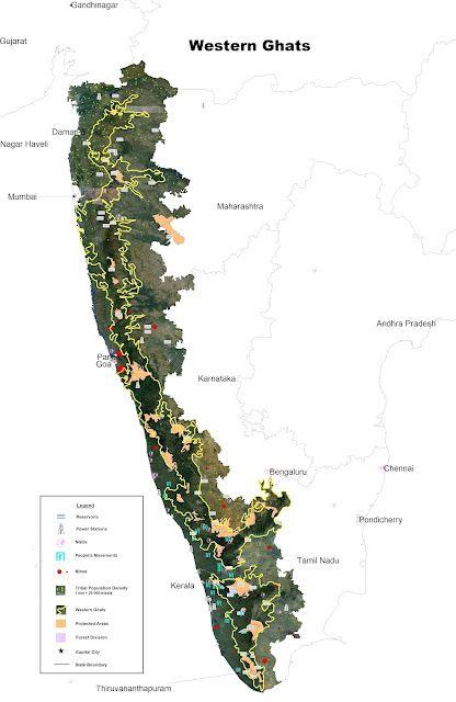
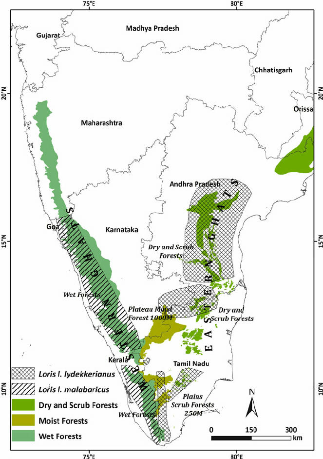
Western Ghats in India Map


Western Ghats States
The Western Ghats extend 30 to 50 kilometres inland and parallel to India’s western shore. India’s Ghats span six states (States of Kerala, Tamil Nadu, Karnataka, Goa, Maharashtra and Gujarat). These mountains run over 1,600 kilometres and occupy an area of about 140,000 km2.


 Calicut Hall Ticket 2025 OUT, Download U...
 JEE Mains Admit Card 2025 Release Date, ...
 NIOS Result 2024 October Exams Out Soon,...


