Table of Contents
India is a vast and diverse country with a wide range of biogeographical zones. These zones are characterized by distinct climate, vegetation, and wildlife patterns. Here we have explained all about biogeographical zones of India
What are Biogeographical Zones?
The scientific study of the distribution of species and ecosystems throughout geological time and space is known as biogeography. Geographic gradients of height, isolation, latitude, and habitat area often cause biological communities and living organisms to differ in a predictable way.
The basic definition of biogeographic regions is “those dominant divisions of the earth’s surface of estimated continental extent, which are attributed by distinct assemblages of animal types.” Having said that, a biogeographic region is essentially a geographic area where plants and animals are categorized and have characteristics in common.
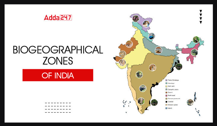
10 Indian Biogeographical Zones
India’s recognised biological variety makes up 8% of the known global biological diversity despite occupying only 2.4% of the total land area. India has been split into 10 biogeographic zones based on its terrain.
Trans-Himalayan Region
It makes up 5.6% of the overall geographical area and consists of the high-altitude, cold, and arid mountain regions of Ladakh, Jammu & Kashmir, North Sikkim, Himachal Pradesh’s Lahaul, and Spiti areas. The largest numbers of wild sheep and goats in the world, as well as other unconventional animals like the Snow Leopard and the migratory Black Necked Crane (Grus nigricollis), may all be found in this area.
Himalayan Zone
It makes up 6.4% of the entire geographical region and has some of the highest peaks on Earth. India is one of the regions with the greatest diversity of habitats and species due to the Himalayan region. For endangered species, a variety of habitats are available in the alpine and subalpine forests, grassy meadows, and moist deciduous forests.
Indian Desert Zone
Large expansions of grassland in the Indian Desert Zone, which makes up 6.6% of the world’s landmass and is home to the Thar and Kutch deserts, provide habitat for several endangered mammal species. These include the wolf (Canis lupus), caracal (Felis caracal), desert cat (Felis libyca), and birds of conservation.
Semi-Arid Region
The semi-arid region, which makes up 16.6% of the overall geographic area, is in between the desert and the Western Ghats’ lush forests. There are two sizable semi-arid zones in Peninsular India. Several man-made and natural lakes, as well as marshy areas, may be found in this semi-arid area. The maximum wildlife biomass is found in this zone’s dominating grass and shrub layer. Sambar (Cervus unicolour) and Chital (Axis axis) are two species that are only found in better-forested hills and moist valley regions, respectively.
Western Ghats
These make up 4% of the entire geographical area. It is one of India’s main areas of tropical evergreen forests and one of the two “hotspots” for biodiversity. Along with a distinctive fauna component of its own, the Western Ghats are home to healthy populations of the majority of the vertebrate species present in peninsular India.
Deccan Plateau
India’s largest biogeographic region, accounting for 42% of the country’s total land area, is the Deccan Plateau. It is a semi-arid terrain that is situated in the Western Ghats’ rain shadow. The best forests in India are found in this bio-geographic region of peninsular India, which is by far the largest region. This plateau includes the states of Madhya Pradesh, Maharashtra, and Odisha. The majority of the woodlands are deciduous.
Gangetic Plain
About 10.8% of the geographical land is made up of the Gangetic plain. The Gangetic plain stretches for hundreds of kilometres and is topographically uniform. Rhinos (Rhinoceros unicornis), Elephants (Elephas maximus), Buffaloes (Bubalus bubalis), Swamp Deer (Cervus duvauceli), Hog-Deer (Axis porcinus), and Hispid Hares (Carprolagus bispidus) are some of the region’s distinctive animals.
North East Region
The North East Region makes up 5.2% of the entire geographical region. This area serves as a merging place for peninsular India and the Himalayan Mountains as well as the transition between the Indian, Indo-Malayan, and Indo-Chinese bio-geographical zones. Thus, the North-East serves as both a biodiversity hotspot and the biogeographical “gateway” for India’s flora and fauna.
Coastal Region
The coastal region constitutes 2.5% of the country’s total land area. Meanwhile, its sandy beaches, mangroves, mud flats, coral reefs, and marine angiosperm pastures make it one of India’s wealthiest and healthiest regions. There are 5,423 kilometres of coastline between Gujarat and the Sunderbans. The Lakshadweep is made up of 25 islets that feature a typical reef lagoon system with a wealth of species.
Andaman and Nicobar Islands
One of India’s three tropical moist evergreen forest zones, it comprises 0.3% of the country’s total land area. The islands are home to a variety of plants and animals that are unique to them. These islands sustain a broad variety of corals and house some of India’s best evergreen forests. Only the Andaman and Nicobar Islands in India have endemic island biodiversity.
Download UGC NET Paper 1 Study Notes PDF
Here we are providing UGC NET Paper 1 Study Notes PDF in below link. Download Biogeographical Zones of India Study Notes PDF through clicking on below link.
Download Biogeographical Zones of India Study Notes PDF
| Read more UGC NET Notes | |
| UGC NET Study Notes for Paper 1 | UGC NET Commerce Notes PDF |


 UGC NET Commerce Syllabus 2025 PDF Downl...
 UGC NET Philosophy Syllabus 2025 PDF Dow...
 PMMMNMTT for NEP 2020, Check details Her...


