Table of Contents
One of the most sacred rivers of India is the Cauvery River System, which flows in South India. This river originates from the Brahmagiri Hill in the Western Ghats of South Karnataka and is one of the most important rivers in South India. The Cauvery River System crosses four states of India and merges into the Bay of Bengal. It covers a total distance of 800 kilometers from its origin to the Bay of Bengal. In this article, we will cover all the important points of the Cauvery River System which are important from the UPSC exam point of view.
Cauvery River System
The Cauvery River system (also known by the anglicized name Cauvery) is one of the major rivers in South India flowing through the states of Karnataka and Tamil Nadu. The Cauvery river system covers four states of India: Karnataka, Tamil Nadu, Kerala, and Puducherry. The system covers a total area of 81,155 square kilometres, which is 2.7 percent of India’s total area. Before merging into the Bay of Bengal, the Cauvery forms a fertile delta known as the ‘Garden of South India’. Cauvery River is also known as the “Ganga of South India”
Cauvery River Origin
The Cauvery River originates from Talakaveri in the Western Ghats in the Brahmagiri Range, near Cherangala village in Kodagu district of Karnataka, at an elevation of 1341 m above sea level. The river system covers a total area of 81,155 square kilometres, which is 2.7 per cent of the total area of India.
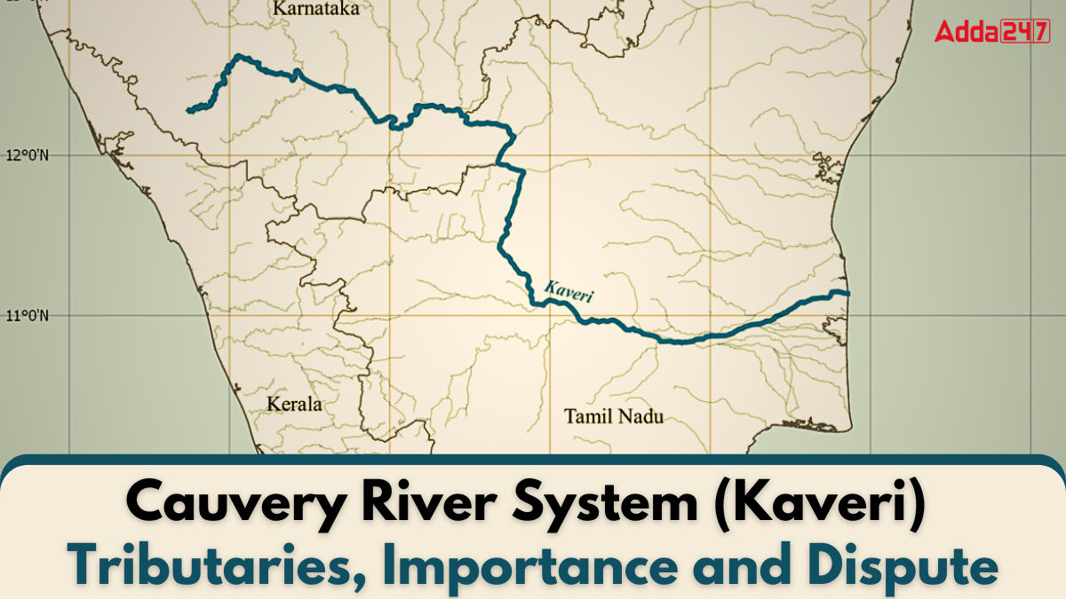
Cauvery River Map
The Kaveri River covers a distance of about 800 km from its origin to the Bay of Bengal. The river flows mainly through the states of Karnataka and Tamil Nadu, with 416 km flowing in Tamil Nadu and 320 km in Karnataka. In the remaining 64 km, it passes through Kerala and Puducherry. The flow direction of the Kaveri River is from northwest to southeast. It is a dense river that forms a fertile delta before emptied into the Bay of Bengal.
, Tributaries, Importance and Dispute 3")
Cauvery River Length
The Cauvery River spans a distance of approximately 800 kilometers from its origin in the Western Ghats to its confluence with the Bay of Bengal. It primarily flows through the states of Karnataka and Tamil Nadu, covering 320 kilometers in Karnataka and 416 kilometers in Tamil Nadu. The remaining 64 kilometers of its journey take it through Kerala and Puducherry. The river flows in a northwest to southeast direction, and before merging into the Bay of Bengal, it forms a fertile delta known as the ‘Garden of South India.’ This river is also referred to as the “Ganga of South India” due to its significance.
| Section | Distance Covered (km) |
|---|---|
| Karnataka | 320 |
| Tamil Nadu | 416 |
| Kerala and Puducherry | 64 |
| Total | 800 |
Cauvery River Tributaries
The Kaveri River is called the “Ganga of South India” and the tributaries of Cauvery are divided into two parts, the first part is called the right bank tributaries of Cauvery and the second part is called the left bank tributaries of Cauvery.
Left Bank Tributaries
Like other rivers, Kaveri river also has tributaries. The major tributaries coming from the left bank are Harangi, Shimsha, Hemavati and Arkavathi. We will share detailed information about left bank tributaries which are important from the exam point of view.
Right Bank Tributaries
As you have seen, Cauvery has many tributaries on its left bank, similarly, it has many tributaries on its right bank too, including Lakshmanatirtha, Kabani, Suvarnavati, Bhavani, Noyyil and Amaravati which join Cauvery from the right. We will share information about all of them which are important from the exam point of view.
| Left Bank Tributaries | Right Bank Tributaries |
|---|---|
| Harangi | Lakshmanatirtha |
| Shimsha | Kabani |
| Arkavathi | Suvarnavati |
| Hemavati | Bhavani |
| Noyyil | |
| Amaravati |
Cauvery River Major Tributaries
The Cauvery River has many tributaries, but some of the major tributaries important for UPSC exam are: Hemavati, Shimsha, Kabani, Amaravati, Lakshmanatirtha, Arkavathi
Hemavati
The Hemavathi River originates in the Western Ghats near Ballalarayana Durga in Chikmagalur district of Karnataka at an altitude of 1219 meters. The total length of this river is 245 kilometers. The Hemavathi River flows through Hassan district and Mysore district before joining the Kaveri River near Krishnarajasagar.
Shimsha
The Shimsha River originates from the Devarayan Durga Hills at an altitude of 914 meters in Tumkur district of Karnataka. The total length of this river is 221 kilometers. The Shimsha River meets the Kaveri River at Shimsha and has a catchment area of 8469 square kilometers.
Kabani
The Kabini River originates from the Western Ghats of the Pakaramathalam Hills in North Wayanad, Wayanad district of Kerala, from where two streams Mannantoddippuzha and Panamarampuzha originate. The river is a perennial river, with a width between 150 and 200 metres and a total length of about 240 kilometres. The drainage basin of the Kabini River covers an area of 7,040 square kilometres.
Amaravati
The Amaravati River originates from the Western Ghats (Anaimalai) Naimkad in the Idukki district of the state of Kerala. Its length is about 282 kilometers. This river is also called Pournami and it stretches for about 175 kilometers down the Manjampatti valley from the border of Kerala and Tamil Nadu.
Lakshmanatirtha
The Lakshmantirtha River originates from the Brahmagiri Hills in the Kodagu (Coorg) district of Karnataka and is about 180 km long. The river flows eastwards and meets the Kaveri River at the Krishnaraja Sagar Lake. The Lakshmantirtha Falls (Irupu Falls), a popular freshwater waterfall on this river, is located on the border of Kerala on the way to the Nagarhole National Park.
Arkavathi
The Arkavathi River originates from the Nandi Hills in the Chikkaballapur district of Karnataka and is about 161 km long. The river merges into the Chikkanayakanahalli Lake near Kanivenarayanapura.
Importance of the Cauvery River System
The Cauvery River, often called the “Ganga of South India,” is a lifeline for Karnataka and Tamil Nadu, providing essential irrigation, drinking water, and supporting agriculture, cultural traditions, and the local economy. Its significance is underscored by historical water disputes and vital ecological contributions.
Agricultural Backbone
- Vital for irrigation in Karnataka and Tamil Nadu, supporting the agriculture of rice, sugarcane, and other crops.
- The fertile delta formed by the river is known as the ‘Garden of South India’.
Drinking Water Supply
- Primary source of drinking water for cities like Bengaluru, Mysore, and numerous towns in Tamil Nadu.
Cultural and Religious Significance
- Revered as the “Ganga of South India”.
- Hosts various religious and cultural events along its banks, fostering local traditions.
Economic Importance
- Supports fishing and aquaculture activities, contributing to the local economy.
- Hydroelectric power generation from dams like Mettur and Krishna Raja Sagara boosts regional power supply.
Environmental Significance
- Maintains ecological balance by supporting diverse flora and fauna in its basin.
- Key to sustaining wetlands, forests, and wildlife sanctuaries in its vicinity.
Historical Disputes
- The Cauvery water dispute underscores its importance, leading to legal and political engagements to ensure fair water distribution among Karnataka, Tamil Nadu, Kerala, and Puducherry.
- The 2018 Supreme Court ruling and the establishment of the Cauvery Water Management Authority highlight its critical role in interstate water sharing.
Cauvery Water Dispute
The Cauvery River is a major river in South India, which is extremely important for agriculture and drinking water. The river flows through three states – Karnataka, Tamil Nadu, Kerala – and one union territory Puducherry. There has been a dispute between these states for more than a century over the sharing of Cauvery water.
Initial Dispute
The Cauvery water dispute between Karnataka and Tamil Nadu began in 1974, when Karnataka began diverting Cauvery water without Tamil Nadu’s consent. This escalated tensions between the two states, as water shortages led to water supply problems in both states.
Water sharing
The Cauvery river water is divided among four states:
TMC- Thousand million cubic feet (1,000,000,000 = 109 = 1 billion)
- Tamil Nadu: 404.25 TMC
- Karnataka: 284.75 TMC
- Kerala: 30 TMC
- Puducherry: 7 TMC
Supreme Court Decision 2018
In 2018, the Supreme Court declared the Cauvery a national property and largely upheld the water-sharing arrangement determined by the Cauvery Water Disputes Tribunal (CWDT). It directed the central government to notify the Cauvery Management Plan.
Cauvery Water Management Plan
The central government notified the ‘Cauvery Water Management Plan’ in June 2018, under which the ‘Cauvery Water Management Authority’ and the ‘Cauvery Water Regulation Committee’ were constituted. The plan aims to ensure fair and equitable distribution of Cauvery river water.

 TSPSC Group 1 Question Paper 2024, Downl...
 TSPSC Group 1 Answer key 2024 Out, Downl...
 UPSC Prelims 2024 Question Paper, Downlo...