Table of Contents
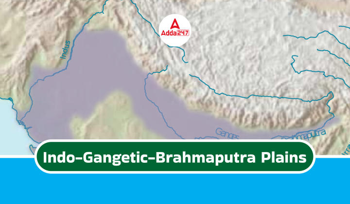
The Indo-Gangetic-Brahmaputra Plains, nestled between the Himalayas and Deccan Plateau, make up the world’s biggest flat area made of soil and sand washed down by rivers. Over millions of years, the Indus, Ganga, and Brahmaputra rivers have carved out these fertile plains, which are like the farming centre of India. They stretch for a whopping 3,200 kilometres and have really good soil, plenty of water, and a nice climate for growing crops.
The plains are split into the Indus, Ganga, and Brahmaputra sections, each shaped by the main river it’s named after. These plains are full of life and history, playing a big role in India’s geography and past. This article gives a comprehensive guide to learning the Indo-Gangetic-Brahmaputra Plain, invaluable for those preparing for the UPSC Civil Service examination in Geography.
Indo-Gangetic-Brahmaputra Plains
- Largest Alluvial Plain: The Indo-Gangetic-Brahmaputra Plains is the world’s biggest alluvial plain, formed by sediment deposits from the Indus, Ganga, and Brahmaputra rivers.
- Himalayan Cradle: These plains lie nestled between the majestic Himalayas to the north and the Deccan Plateau to the south.
- Fertile Breadbasket: The rich alluvial soil makes the region incredibly fertile, turning it into India’s agricultural powerhouse. Crops like wheat, rice, and sugarcane flourish here.
- Imposing Length: The plains stretch for a staggering 3,200 kilometres, starting from the Indus River mouth in Pakistan to the Ganga River delta in Bangladesh.
- Sub-divisions: The vast expanse can be divided into three sections: the Indus Plain in the west, the Ganga Plain dominating the centre, and the Brahmaputra Plain in the east.
- Densely Populated: The fertile lands and favourable conditions have led to a high population density in the region.
- Cultural Richness: The Indo-Gangetic-Brahmaputra Plains boast a vibrant cultural heritage nurtured for centuries.
Indo-Gangetic-Brahmaputra Plains Formation
- Before the collision of the Indian Plate with the Eurasian Plate, rivers flowing into the Tethys Sea deposited significant sediment volumes within the Tethys Geosyncline, a large depression.
- The Himalayas were formed from these sediments, which experienced uplift, folding, and compression due to the northern movement of the Indian Plate.
- The northward movement of the Indian Plate also resulted in the creation of a trough to the south of the Himalayas.
Features of Indo-Gangetic-Brahmaputra Plains
- The Indo-Gangetic-Brahmaputra Plain is globally recognized as the largest alluvial tract.
- Extending approximately 3,200 kilometers from the mouth of the Indus to the mouth of the Ganga, the Indian segment covers around 2,400 kilometres.
- Its northern boundary is marked by the Shiwalik hills, while the southern boundary follows an irregular line along the northern edge of Peninsular India.
- Bordered by the Sulaiman and Kirthar ranges to the west and the Purvanchal hills to the east.
- The width varies, widest in the west at about 500 kilometres, tapering towards the east.
- Alluvium deposits reach depths up to 6,100 meters, notably in the cones or alluvial fans of rivers like the Kosi in the north and the Son in the south.
- Remarkably level across its expanse, with an average elevation of about 200 meters above sea level, peaking at 291 meters near Ambala.
- This elevation forms the watershed between the Indus and Ganga river systems.
- The average gradient from Saharanpur to Kolkata is 20 centimetres per kilometre, decreasing to 15 centimetres per kilometer from Varanasi to the Ganga Delta.
Rivers and Additional Sediment
- The uplift of the Himalayas and glacier formation led to the emergence of many new rivers.
- These rivers, along with glacial erosion, added more sediment, intensifying the filling of low areas.
- Accumulation of sediment caused the retreat of the Tethys Sea.
- Over time, the low areas were filled with sediment, gravel, and rock debris, resulting in a featureless flat land called a monotonous aggradational plain.
- The Indo-Gangetic Plain is a significant example of such a plain, formed by the deposition of river sediments.
- While upper peninsular rivers also contributed to the plain formation, their impact was minimal.
- Presently, the depositional activity of major river systems like the Indus, Ganga, and Brahmaputra dominates, leading to the term “Indo-Gangetic-Brahmaputra Plain” for this curved plain.
Depositional Activities in Indo-Gangetic-Brahmaputra Plains
- During the initial stages of sediment upliftment, existing rivers experienced multiple changes in their course and underwent rejuvenation cycles, known as the perpetual youth stage of rivers (Fluvial Landforms).
- Rejuvenation occurred due to intense headward and vertical downcutting of soft sediment layers overlying harder rock formations.
- Headward erosion, involving erosion at the origin of a stream channel causing it to move backwards against the flow direction, and vertical erosion of the river valley were predominant in the early stages, while lateral erosion became more prominent in later stages.
- This erosional activity contributed significant quantities of conglomerates (detritus), consisting of rock debris, silt, clay, etc., which were transported downslope by the rivers.
- These conglomerates were deposited within the depression known as the Indo-Gangetic Trough or Indo-Gangetic Syncline, situated between peninsular India and the convergent boundary, where the present-day Himalayas are located. The base of this geosyncline comprises hard crystalline rock formations.

 TSPSC Group 1 Question Paper 2024, Downl...
 TSPSC Group 1 Answer key 2024 Out, Downl...
 UPSC Prelims 2024 Question Paper, Downlo...