Table of Contents
Krishna River System: Talking about the rivers of India, the rivers of South India, also known as peninsular rivers, play an important role in South India. One of these peninsular rivers is the Krishna River system. The Krishna River is the second largest among the peninsular rivers that flow from west to east. The River system is India’s fourth largest river system, coming after the Indus, Ganges, and Godavari rivers. In today’s article, we will get detailed information about the Krishna River system, which will prove beneficial for the UPSC Pre and Mains exams.
Krishna River System
The Krishna river system is one of the major river systems of India. The river passes through four states of peninsular India. Starting from Mahabaleshwar in Maharashtra, the river reaches the Krishna district of Andhra Pradesh and eventually merges into the Bay of Bengal. During its journey, it covers a total distance of 1400 km. The Krishna River has the highest flow in Andhra Pradesh.
This river system covers about 8% of the total geographical area of India and 75% of its water is used for agriculture and other purposes. The Krishna River has many tributaries, the major ones of which are Tungabhadra and Bhima. The Tungabhadra, which joins from the right, covers a distance of about 531 km. The largest tributary from the left is Bhima, which joins the Krishna River after a journey of 861 km.
Origin of Krishna River System
The Krishna river system originates from the Western Ghats and takes its origin from Jor village in Mahabaleshwar, Satara district of Maharashtra. The river passes through Maharashtra, enters the state of Karnataka, then flows into the state of Telangana. Thereafter, it flows into Andhra Pradesh forming the border of Telangana and Andhra Pradesh and finally merges into the Bay of Bengal at Hamsaladhiv in Krishna district of Andhra Pradesh.
Length of Krishna River System
The Krishna River system spans 1,400 km, originating from the Western Ghats and flowing eastwards into the Bay of Bengal. It traverses four peninsular states in India. The river’s catchment area is 258,948 square kilometers, constituting 8% of India’s total geographical area. This makes it one of the largest river systems in peninsular India. The Krishna River flows 305 kilometers in Maharashtra, 483 kilometers in Karnataka, and 612 kilometers in Telangana and Andhra Pradesh combined.
| State | Length in Kilometers (km) | Length in Miles (mi) |
|---|---|---|
| Maharashtra | 305 km | 190 mi |
| Karnataka | 483 km | 300 mi |
| Telangana + Andhra Pradesh | 612 km | 380 mi |
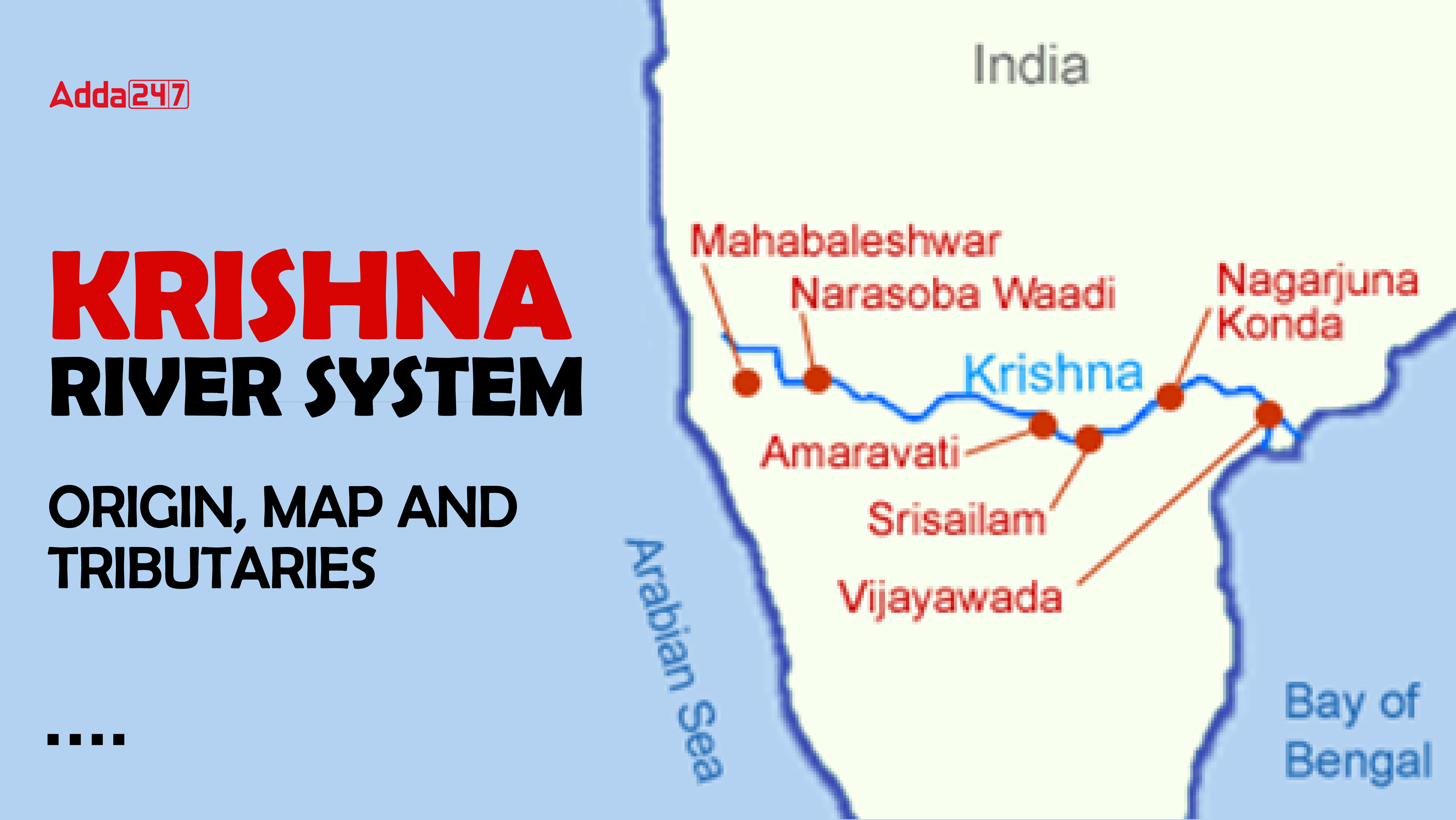
Map of Krishna River System
If you want to understand or read the river system well, the most useful way is to take the help of a map, through which you can get all the information at a glance. It is also important to understand the Krishna river system through a map because it passes through four states of India. Its maximum water flow is in Telangana and Andhra Pradesh, which can be easily seen and understood through the map.

Tributaries of Krishna River System
The Krishna river system is one of India’s major rivers, comprising many tributaries. These tributaries are divided into two groups: left-bank tributaries and right-bank tributaries. The Tungabhadra is the largest right-bank tributary, joining the Krishna River after covering 531 km. The joining of the Tunga and Bhadra rivers forms it. The largest left bank tributary is the Bhima, which flows for 861 km.
Also Read: Rivers of India
Left Bank Tributaries
Right Bank Tributaries
The right bank tributaries of Krishna river are Koyna, Panchganga, Dudhganga, Ghataprabha, Malaprabha, Tungabhadra, and Kudali (Niranjana) Venna. The largest right bank tributary is Tungabhadra, which flows a total distance of 531 km and joins Krishna river. Tungabhadra river is formed by the confluence of Tunga and Bhadra rivers.
| Left Bank Tributaries | Right Bank Tributaries |
| Yerla | Koyna |
| Bhima | Panchganga |
| Dindi | Dudhganga |
| Musi | Ghataprabha |
| Paleru | Malaprabha |
| Munneru | Tungabhadra |
| Kudali (Niranjana) Venna |
Major Tributaries of Krishna River System
Krishna river has many tributaries, but some of these major rivers are particularly important for agriculture and other purposes. These major tributaries include Tungabhadra, Ghatprabha, Malaprabha, Bhima, Musi and Munneru. All these rivers together increase the water resources of Krishna river and play an important role for agriculture and water supply in various regions. Now we will discuss all these rivers in detail.
Tungabhadra
The Tungabhadra River is the largest southern tributary of the Krishna river system. It is formed by the confluence of two rivers, the Tunga and the Bhadra. Both the Tunga and the Bhadra originate from the eastern slopes of the Western Ghats. The total length of the Tungabhadra River is 531 km and its catchment area is spread over 28,000 square kilometers.
Bhima
The Bhima River originates from the Bhimashankar Hills near Karjat on the western edge of the Western Ghats in Pune district of Maharashtra. The total basin area of the Bhima River is 48,631 square kilometers, of which 75 percent is in Maharashtra. The Bhima River is the confluence of the Krishna and Bhima rivers located on the border of Karnataka state, at the same place where the Bhima River merges with the Krishna River.
Ghatprabha
The Ghataprabha River originates in the Western Ghats at an altitude of 884 meters. The river flows through the state of Karnataka covering a distance of 283 kilometers and then merges with the Krishna River. Ghataprabha is an important tributary of the Krishna River, known for its eastward flow.
Krishna River System for UPSC
Understanding the Krishna River system is crucial for UPSC’s preparation of significant aspects of India’s geographical, environmental, and socio-economic landscape. As the fourth largest river system in India, it traverses four states—Maharashtra, Karnataka, Telangana, and Andhra Pradesh—covering a total length of 1400 km. This river system, originating from Mahabaleshwar in the Western Ghats, is pivotal for agricultural activities, supporting around 8% of India’s geograp
hical area.
Key tributaries like the Tungabhadra and Bhima increase its water resources, making it vital for irrigation and water supply. The detailed knowledge of its tributaries, origin, flow, and catchment area is essential for answering questions related to India’s physical geography, river systems, and their impact on regional development, which are common in both the UPSC Prelims and Mains exams.
| Related Articles | |
| Cauvery River System | Longest River in India |
| Brahmaputra River System | Important Hill Ranges of India |
| Yamuna River System | Drainage System of India |

 TSPSC Group 1 Question Paper 2024, Downl...
 TSPSC Group 1 Answer key 2024 Out, Downl...
 UPSC Prelims 2024 Question Paper, Downlo...