Table of Contents
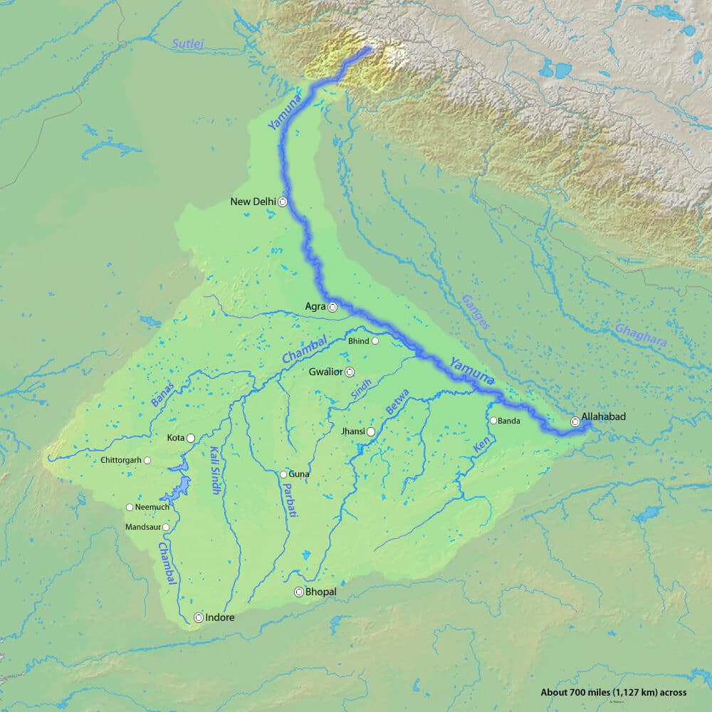
The Yamuna is the largest tributary of the Ganges River. It originates from the Yamunotri Glacier and is approximately 1,376 km (855 miles) long. The Yamuna River system includes several significant tributaries such as the Chambal, Ken, Betwa, Tons, and Sindh.
Understanding the Yamuna River system is crucial for UPSC and other competitive examinations, as it plays a vital role in the geography and hydrology of the region.
Yamuna River System
The Yamuna River system is highly significant for the UPSC exam. It is the second-largest tributary of the Ganges River. Originating from the Yamunotri Glacier in Uttarakhand, the Yamuna River flows through Uttar Pradesh, Haryana, New Delhi, and Himachal Pradesh before merging with the Ganges at Prayagraj.
The Yamuna River system is one of India’s most important water systems, with numerous tributaries joining it. Major tributaries of the Yamuna River include the Chambal, Hindon, Tons, Giri, Sindh, Ken, and Betwa. Understanding the Yamuna River system and its tributaries is crucial for geography and hydrology topics in competitive examinations like UPSC.
Yamuna River Origin
Yamuna River Tributaries
Chambal
The Chambal River, a key tributary in the Yamuna river system, supports the Yamuna along its 930 km journey and meets it near Etawah. Originating from the Janapav Hills of the Vindhya Range in Madhya Pradesh, the Chambal River extends for 960 kilometers. Its significant tributaries include the Shipra and Banas rivers.
Tons
Tons is the longest tributary of the Yamuna River. This river flows through the western part of the Himalayan range, Garhwal (Uttarakhand). This river originates at an altitude of 3900 m and joins the Yamuna below Kalsi near Dehradun in Uttarakhand. It is one of the largest perennial Indian Himalayan rivers.
Hindon
The Hindon River is an important tributary of the Yamuna River. The Hindon River originates in the Upper Shivalik (lower Himalayas). The river travels 400 kilometres (250 mi) through Muzaffarnagar district, Meerut district, Baghpat district, Ghaziabad, Noida and Greater Noida (outside Delhi) before joining the Yamuna. The total length of the Hindon River is about 400 km.
Betwa
The Betwa River is a tributary of Yamuna River. Betwa river originates from Bhopal district of Madhya Pradesh at an altitude of 470 meters. It flows in a north-easterly direction and passes through the states of Madhya Pradesh and Uttar Pradesh. During its journey, the river covers a distance of 590 kilometers and finally merges with Yamuna river near Hamirpur at an altitude of 106.68 meters. The Halali and Dhasan rivers are important tributaries of the Betwa River.
Ken
The Ken River originates near Ahirgaon village in the Jabalpur district of Madhya Pradesh, at an altitude of 550 meters above sea level. The river is significant as it flows through the Bundelkhand region of both Madhya Pradesh and Uttar Pradesh, covering a distance of about 427 kilometers (265 miles).
The Ken River starts its journey from Ahirgaon village in Jabalpur and ends near Chilla village in Uttar Pradesh, where it merges with the Yamuna River at an altitude of about 95 meters. Important tributaries of the Ken River include the Sonar, Bearma, Kopra, Bewas, Urmil, Mirhasan, Kutni, and Kali. Understanding the Ken River’s course and its tributaries is essential for UPSC and other competitive examinations.
Sind
Sindh River originates from the Malwa Plateau in Vidisha district. Sindh River is one of the second largest right bank tributaries of Yamuna. It flows in a north-easterly direction for a distance of 415 km before joining Yamuna 20 km upstream of Auraiya. Parvati and Kunwari are important tributaries on the left bank of Sindh River while Pahuj is on its right bank.
Giri
Giri River is the main source of water in south-eastern Himachal Pradesh, hence it becomes the most important river of Himachal Pradesh. Giri River is an important tributary of Yamuna River. This river is famous as Giri River Jubbal, Rohru Hills, which originates from Kupar Peak just above Jubbal town after flowing through the Shimla Hills.
Yamuna River Map
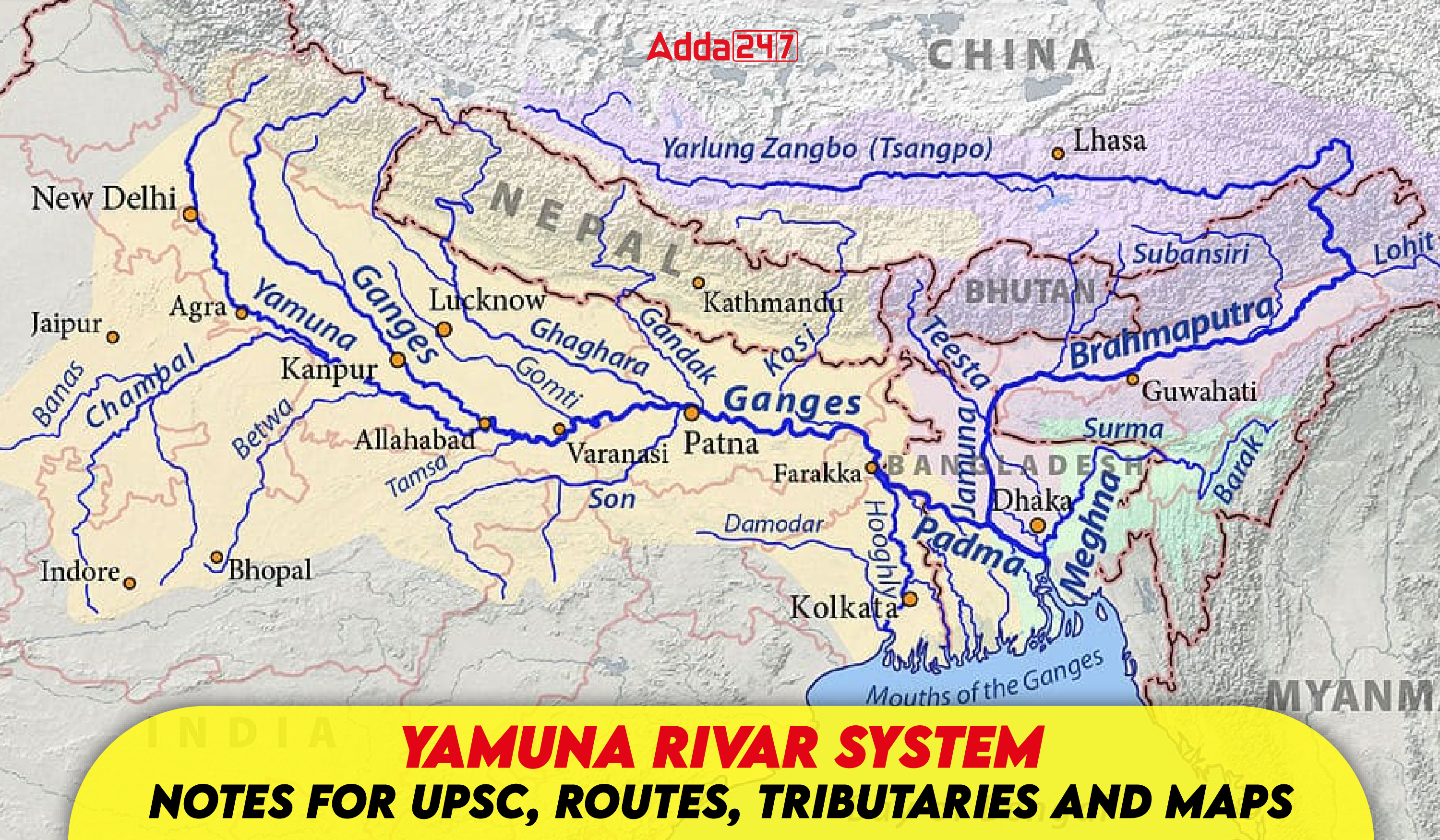
The Yamuna River, just like the Ganges River, is fed by many tributaries. Understanding the complex network of these rivers, just by reading text, can be difficult. To overcome this challenge, maps are an invaluable tool. On the map, we can clearly see the flow of different rivers, their meeting points, and their relationship with the Yamuna. This approach helps us understand the overall information of all the tributaries of the Yamuna more easily and accurately.
Here are some advantages of using maps:
Visual presentation: Maps show the routes of rivers at a glance, making it easier to understand their complexity.
Spatial relationships: We can see how rivers relate to each other and where they join the Yamuna.
Comprehensive information: Maps often also show the length of rivers, water levels, and other important information.
Why is Yamuna considered sacred from a religious point of view?
Just like the river Ganga is worshipped in Hinduism, Yamuna is also revered in Hinduism and is worshipped as the goddess Yamuna. According to Hindu beliefs, the river Yamuna is considered as the daughter of the Sun God and the sister of Yama, the god of death, which is why she is also known as Yami. Popular Hindu legends state that bathing in the holy waters of Yamuna frees a person from the sufferings associated with death. This deep spiritual significance gives Yamuna a central place in Hindu rituals and mythology.
Yamuna River System Issues and Challenges
Yamuna River, seen as the major river of North India, is facing serious challenges like pollution, water scarcity, and encroachment. Industrial and domestic waste, illegal construction, and death of aquatic life are affecting its environmental balance, threatening its existence. What are the issues and challenges regarding Yamuna River from the point of view of UPSC? All those topics have been discussed in detail below.
Yamuna River System – Pollution
- A large amount of chemical waste from industrial units in cities like Delhi, Agra and Mathura is discharged into the river, polluting the water.
- The direct discharge of domestic sewage into the river without treatment, severely affects the water quality.
- Runoff of chemical fertilizers and pesticides used in agricultural operations also pollutes the river.
Water scarcity
- Excessive water extraction for agriculture, industry and domestic use is leading to a decrease in the water level in the river.
- Sedimentation in the river course is obstructing the flow of water, leading to a decrease in water availability.
Encroachment of the river
- Illegal construction and encroachment on the river banks is obstructing the natural flow of the river.
- Illegal sand mining from the river banks is affecting the environmental balance of the river.
- Oxygen levels in the river are decreasing due to pollution, leading to the death of fish and other aquatic life.
- Polluted water and sedimentation is reducing the biodiversity of the river.
Yamuna River System Challenges
- The laws made to save the river are not being implemented effectively.
- There is a lack of awareness and participation among the general public towards river conservation.
Yamuna River System for UPSC
General knowledge is the main pillar of UPSC and among them, geography is the most important subject for UPSC. The topic called the heart of geography is rivers from which questions are bound to be made in the exam. Yamuna River is the largest tributary of the Ganga river in India and if we look at it from the point of view of the UPSC exam, then questions related to the Yamuna river can be seen in every exam. The Yamuna River system is a critical topic for the UPSC exam due to its geographical, cultural, and economic significance. Understanding the river and its tributaries is essential for answering questions in the Geography section of the exam. Through this article, you can answer all types of questions related to the Yamuna river system.
| Related Articles | |
| Brahmaputra River System | Soil Types and Their Distributions |
| Longest River in India | Himalayas Longitudinal Division |
| Western And Eastern Coastal Plains of India | Seasons of India |


 TSPSC Group 1 Question Paper 2024, Downl...
 TSPSC Group 1 Answer key 2024 Out, Downl...
 UPSC Prelims 2024 Question Paper, Downlo...


